The 2025 Atlantic hurricane season officially ended on November 30, and it will be remembered for rapid intensification to record-breaking pressure drops. Even without a single U.S. hurricane landfall, the season proved that impact isn’t defined by direct hits — distant storms drove days of dangerous surf, rip currents, and flooding far from their centers.
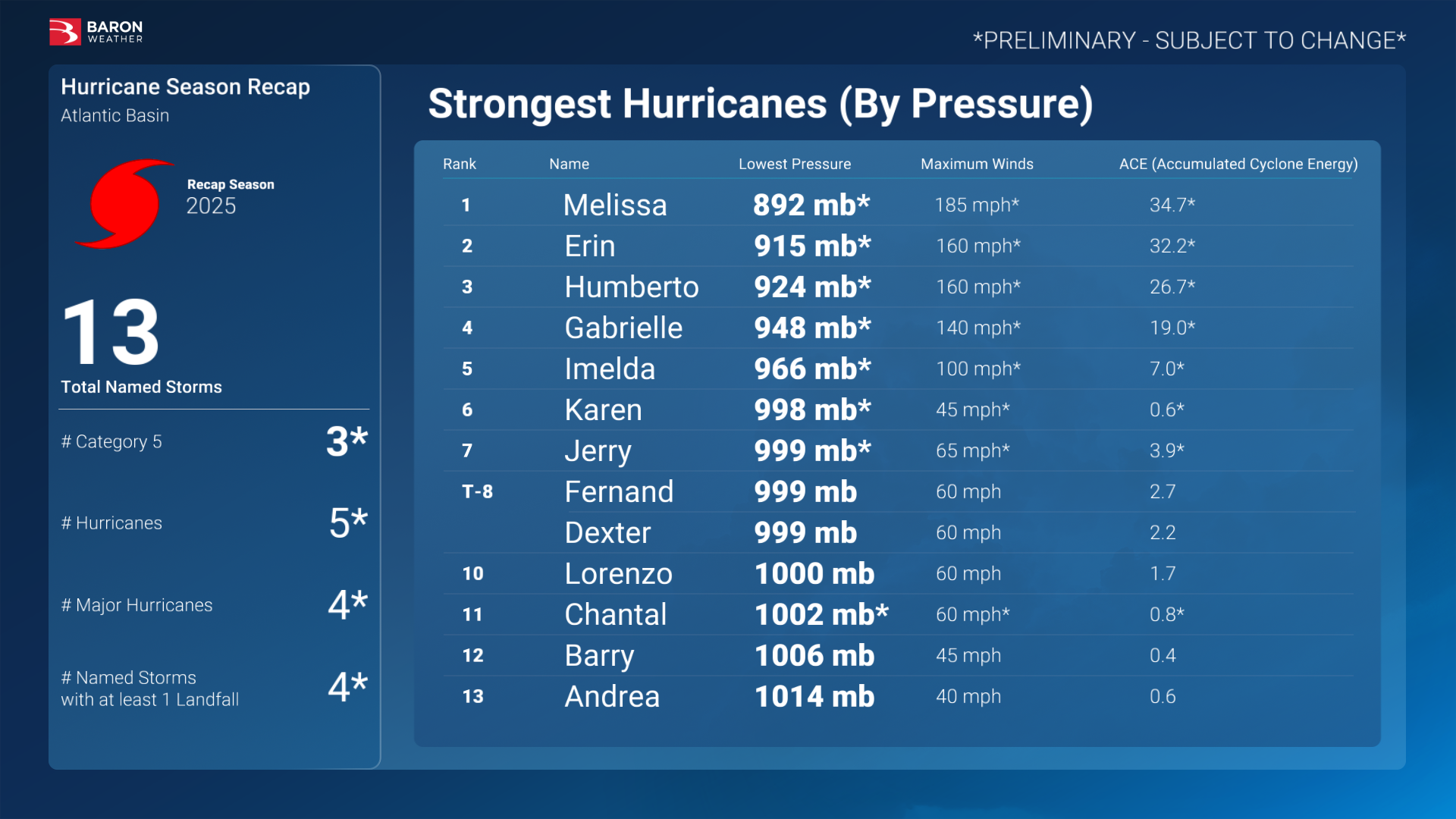
The tropics delivered a vivid reminder that preparation and awareness are just as critical as the forecast itself. By season’s end, the Atlantic had produced 13 named storms, 5 hurricanes, and 4 major hurricanes (Category 3 or higher), with Accumulated Cyclone Energy (ACE) about 10% above the 1991–2020 average.
Season in a Snapshot
- Activity: Overall ACE was above average for the season, though the total number of storms and hurricanes was near to slightly below normal, with several high-end peaks noted by the National Hurricane Center.
- U.S. landfalls: There were no U.S. hurricane landfalls through early November; Tropical Storm Chantal was the only named system to come ashore.
- Preseason outlooks: NOAA’s Climate Prediction Center anticipated an above- to near-normal season, and the final totals and ACE ended up on the higher end of that forecast range.
The Headliners
- Hurricane Erin (August)
Erin became the season’s first major hurricane and briefly reached Category 5 north of the Leeward Islands before arcing away from the U.S. mainland. Even without making landfall, it generated days of dangerous surf and rip currents along the East Coast—an example that distance isn’t a guarantee of protection. - Hurricane Melissa (Late October)
The season’s defining event: Hurricane Melissa, a devastating Category 5 that struck Jamaica. Melissa’s central pressure bottomed out near 892 mb—tying the third-lowest on record in the Atlantic and the strongest landfall on record in the basin by pressure, before racing northeast past Bermuda. The human and infrastructure toll across Jamaica was devastating. - Hurricane Humberto (Late September)
Humberto rapidly intensified over the open Atlantic and also reached Category 5. While it stayed over water, swells and coastal flooding affected parts of the Caribbean, Bermuda, and the U.S. East Coast. Its energy later helped spawn a strong North Atlantic windstorm. - Tropical Storm Chantal (Early July)
A quick-hitting but high-impact U.S. event: Chantal made landfall near Litchfield Beach, South Carolina, then soaked central North Carolina with significant flash flooding. It’s the reminder that tropical-storm-force systems can be flood disasters, especially inland.
Three big themes from 2025
- Rapid intensification (RI) remains the wildcard.
Hurricanes Erin and Humberto both strengthened quickly over exceptionally warm waters, while Melissa’s explosive deepening was historic. RI events are occurring more frequently and with less lead time, creating new challenges for forecasting and preparedness. - High ACE without high U.S. landfall counts is absolutely possible.
Favorable steering patterns and timely troughs kept the most intense storms offshore of the continental U.S., even as basin wide energy climbed well above normal. It’s a reminder that planning can’t rely on landfall statistics alone. - “Indirect” impacts were a direct problem.
From rip currents and long-period swells to extended coastal flooding and beach erosion, many storms produced significant hazards far from their centers. These effects stress the need for public messaging and operations to treat surf and surge as primary risks, too.
How organizations used Baron this season
- Early awareness & situational intel: Long-range guidance and RI-risk indicators within Baron data streams helped organizations elevate readiness before intensity spikes, improving lead time for planning and response.
- Custom & targeted alerting: Weather Logic and Baron Threat Net enabled geo-specific alerts—such as rip current windows, rainfall thresholds, and surge risks—supporting common operating pictures for EOCs, utilities, and transportation partners.
- Seamless Integration: Organizations incorporated Baron models and observation layers into custom dashboards, GIS platforms, and operational tools, creating a connected workflow with a single, consistent view of evolving conditions, enabling quicker, more unified decisions.
Looking ahead to 2026
The 2025 season showed that distance doesn’t define impact. The biggest storms aren’t always the closest ones. Powerful hurricanes can remain far offshore yet still generate weeks of hazardous seas, surf, and coastal flooding, while a “minor” tropical storm can deliver some of the year’s most damaging U.S. flooding.
With ocean heat still running high across key development regions, off-season planning should account for greater rapid intensification potential, longer swell events, and broader wind fields. Now is the time to review thresholds, refine communication plans for non-landfall hazards, and ensure your data and tools are aligned with the conditions that pose the greatest risk.
As planning begins for 2026, the Baron team can help you turn this season’s lessons into stronger preparedness with tailored data, insight, and decision-support tools designed for what comes next.
